
Related Images


Download:
| Tiny | 99x128 | View | Download |
| Small | 198x256 | View | Download |
| Medium | 396x512 | View | Download |
| Large | 792x1024 | View | Download |
| Original png | 1555x2008 | View | Download |
| Original as jpg | 1555x2008 | View | Download |
This image was acquired from
wikimedia. It was marked as Public Domain or CC0 and is free to use. To verify, go to the source and check the information there.
Looking for more info about this image?
Try a Google Reverse Image Search for it.
Try a Google Reverse Image Search for it.
Keywords from Image Description:
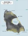
StPaul Map. Map of Saint Paul Island French Southern and Antarctic Territories Carte de l'Ile SaintPaul Terres australes et antarctiques franaises own varp Atelier graphique carte le SaintPaul Maps in French Maps of SaintPaul and New Amsterdam Islands