
Related Images


Download:
| Tiny | 103x128 | View | Download |
| Small | 207x256 | View | Download |
| Medium | 414x512 | View | Download |
| Large | 829x1024 | View | Download |
| Original png | 1620x2000 | View | Download |
| Original as jpg | 1620x2000 | View | Download |
This image was acquired from
wikimedia. It was marked as Public Domain or CC0 and is free to use. To verify, go to the source and check the information there.
Looking for more info about this image?
Try a Google Reverse Image Search for it.
Try a Google Reverse Image Search for it.
Keywords from Image Description:
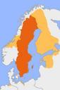
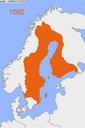
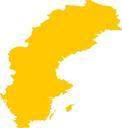
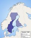
Sweden . This is map of Sweden around the year Incorrect The colonialization of Lappland inner northern Sweden did not start until and Norrbotten coast until some time after Hlsingland had loose connection to Sweden until Created by Ningyou own assumed Ningyou map Maps of the history of Sweden Maps of the history of Scandinavia