
Related Images


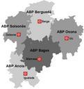
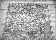
This image was acquired from
wikimedia. It was marked as Public Domain or CC0 and is free to use. To verify, go to the source and check the information there.
Looking for more info about this image?
Try a Google Reverse Image Search for it.
Try a Google Reverse Image Search for it.
Keywords from Image Description:
TabulaGermaniae. en Map of Central Europa of Nikolas Cusa cs Mapa stedn Evropy Mikule Kusnskho MEURER Peter The History of Cartography Chapter Cartography in the German Lands Chcago The University of Chicago Press ISBN Mikul Kusnsk Cczero Old maps of the Holy Roman Empire Maps made in the th century Late Middle Ages