Related Images


Download:
| Tiny | 191x128 | View | Download |
| Small | 382x256 | View | Download |
| Medium | 765x512 | View | Download |
| Original | 800x535 | View | Download |
This image was acquired from
wikimedia. It was marked as Public Domain or CC0 and is free to use. To verify, go to the source and check the information there.
Looking for more info about this image?
Try a Google Reverse Image Search for it.
Try a Google Reverse Image Search for it.
Keywords from Image Description:
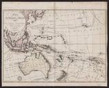
Tasman's track. This is map showing the track taken by Abel Tasman in Project Gutenberg of Australia edition of Early Voyages in Terra Australis The image is located at gutenberg net au Original map dates to the th century Early Voyages in Terra Australis was published in Primarily Abel Tasman presumably some professional cartographers