
Related Images


This image was acquired from
wikimedia. It was marked as Public Domain or CC0 and is free to use. To verify, go to the source and check the information there.
Looking for more info about this image?
Try a Google Reverse Image Search for it.
Try a Google Reverse Image Search for it.
Keywords from Image Description:
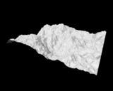
Terrain rendering. en Terrain rendering VisIt can read several file formats common in the field of Geographic Information Systems GIS allowing you to plot raster data such as terrain data in your visualizations The featured image shows plot of DEM dataset containing mountainous areas near Dunsmuir CA Elevation lines are added to