
Related Images

Download:
| Tiny | 74x128 | View | Download |
| Small | 149x256 | View | Download |
| Medium | 299x512 | View | Download |
| Large | 599x1024 | View | Download |
| Original | 1211x2069 | View | Download |
This image was acquired from
wikimedia. It was marked as Public Domain or CC0 and is free to use. To verify, go to the source and check the information there.
Looking for more info about this image?
Try a Google Reverse Image Search for it.
Try a Google Reverse Image Search for it.
Keywords from Image Description:
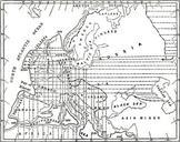
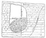
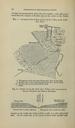
The Quarterly journal of the Geological Society of London . PROCEEDINGS OF THE GEOLOGICAL SOCIETY of about one hundred feet above the riversurface and when mea sured from the summit of Boulderclay on the north to the Chalk Fig Geological Shetch Map of part of the Valley of the Little Oiise River Fits Dournkc Ration' Ferruginous