
Related Images

Download:
| Tiny | 77x128 | View | Download |
| Small | 154x256 | View | Download |
| Medium | 308x512 | View | Download |
| Large | 616x1024 | View | Download |
| Original | 1917x3186 | View | Download |
This image was acquired from
wikimedia. It was marked as Public Domain or CC0 and is free to use. To verify, go to the source and check the information there.
Looking for more info about this image?
Try a Google Reverse Image Search for it.
Try a Google Reverse Image Search for it.
Keywords from Image Description:
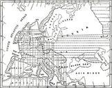
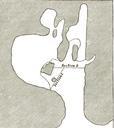
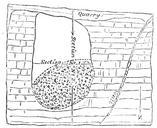
The Quarterly journal of the Geological Society of London . WARD LAKEDISTRICT GLACIATION with the Buttermere and Borrowdale waters by the straits of Scarf Gap and Skiddaw and Blencathra be separated by strait of some width Fig Contourmap showing the form of the land when the sub mergence had reached feet Scale miles