
Related Images


Download:
| Tiny | 110x128 | View | Download |
| Small | 221x256 | View | Download |
| Medium | 442x512 | View | Download |
| Original png | 708x820 | View | Download |
| Original as jpg | 708x820 | View | Download |
This image was acquired from
wikimedia. It was marked as Public Domain or CC0 and is free to use. To verify, go to the source and check the information there.
Looking for more info about this image?
Try a Google Reverse Image Search for it.
Try a Google Reverse Image Search for it.
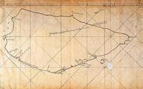
Keywords from Image Description:
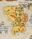
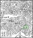
Tsing Yi Island in Yuet Tai Kei. The Position Tsing Yi Island as Chun Fa Lok in the map of Yuet Tai Kei written during Ming Dynasty Original drawn by Kwok Fei Ming Dynasty Modified by Henry Li PDart Old Chinese maps posterior to Old maps of Hong Kong Tsing Yi Artworks missing infobox template