
Related Images


Download:
| Tiny | 149x128 | View | Download |
| Small | 298x256 | View | Download |
| Medium | 596x512 | View | Download |
| Original png | 692x594 | View | Download |
| Original as jpg | 692x594 | View | Download |
This image was acquired from
wikimedia. It was marked as Public Domain or CC0 and is free to use. To verify, go to the source and check the information there.
Looking for more info about this image?
Try a Google Reverse Image Search for it.
Try a Google Reverse Image Search for it.
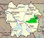
Keywords from Image Description:
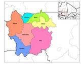
Unmali Kayes Region. Map of the Kayes Region of Mali Additions include new northern road via Diema several towns downgrade of road in fact unpaved from Kayes to Kenieba Solid pink lines are paved dashed are unpaved Addition of National park of Boucle du Baoule Ref Ross Velton Mali Bradt UK and Globe Pequot US ISBN Made with GIMP