
Related Images


Download:
| Tiny | 175x128 | View | Download |
| Small | 350x256 | View | Download |
| Medium | 701x512 | View | Download |
| Large | 1402x1024 | View | Download |
| Original | 2674x1953 | View | Download |
This image was acquired from
wikimedia. It was marked as Public Domain or CC0 and is free to use. To verify, go to the source and check the information there.
Looking for more info about this image?
Try a Google Reverse Image Search for it.
Try a Google Reverse Image Search for it.
Keywords from Image Description:
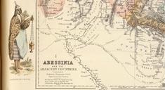
UpperNubiaAndAbyssiniamap. en Map of portion of Northeast Africa in the early from Rand McNally and Co 's fourth edition of Indexed Atlas of the World published in and reproduced in subsequent editions Shown in pink is the southern part of the ephemeral Egyptian empire in the Sudan and East Africa Egyptian Khedive Isma'il Pasha