
Related Images


Download:
| Tiny | 148x128 | View | Download |
| Small | 296x256 | View | Download |
| Medium | 592x512 | View | Download |
| Large | 1184x1024 | View | Download |
| Original png | 6497x5616 | View | Download |
| Original as jpg | 6497x5616 | View | Download |
This image was acquired from
wikimedia. It was marked as Public Domain or CC0 and is free to use. To verify, go to the source and check the information there.
Looking for more info about this image?
Try a Google Reverse Image Search for it.
Try a Google Reverse Image Search for it.
Keywords from Image Description:
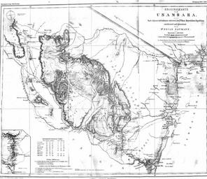
Usambara B. en caption Original map of Usambara After own recordings designed and drawed by Dr Oscar Baumann during the expedition of Dr Hans Meyer Notice in legendNotiz in der Legende br Route MauruiPare Maboga nach den Originalaufnahmen des Linienschifflieutenants Hhnel maps Usambara Mountains Maps of the German East Africa