
Related Images


Download:
| Tiny | 110x128 | View | Download |
| Small | 221x256 | View | Download |
| Original gif | 290x335 | View | Download |
| Original as jpg | 290x335 | View | Download |
This image was acquired from
wikimedia. It was marked as Public Domain or CC0 and is free to use. To verify, go to the source and check the information there.
Looking for more info about this image?
Try a Google Reverse Image Search for it.
Try a Google Reverse Image Search for it.
Keywords from Image Description:
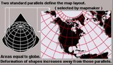
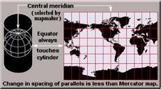
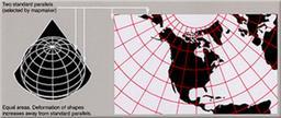
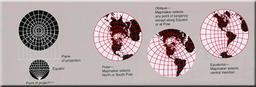
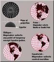
USGS map azimuthal tall. see below Enlarged view azimuthalequidistant projection maps rearranged as taller image from wider USGS file of format See enlarged view below using to expand beyond original size derivative from US Government USGS image file making map sections colored red arranged as taller URL usgs gov User rearranging