
Related Images


Download:
| Tiny | 200x128 | View | Download |
| Small | 401x256 | View | Download |
| Medium | 802x512 | View | Download |
| Original | 1159x739 | View | Download |
This image was acquired from
wikimedia. It was marked as Public Domain or CC0 and is free to use. To verify, go to the source and check the information there.
Looking for more info about this image?
Try a Google Reverse Image Search for it.
Try a Google Reverse Image Search for it.
Keywords from Image Description:
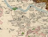
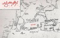
Vermessungsblatt Oeder . en Old map of the area of the artificial ruin near Pillnitz around de Oberer Bereich von Pillnitz Ausschnitt aus einem Vermessungsblatt um entnommen aus Die erste Landesvermessung des Kurstaates Sachsen auf Befehl des Kurfrsten Christian ausgefhrt von Matthias Oeder Entnommen aus Hartmann HansGnther Pillnitz