
Related Images


Download:
| Tiny | 201x128 | View | Download |
| Small | 402x256 | View | Download |
| Medium | 805x512 | View | Download |
| Large | 1610x1024 | View | Download |
| Original png | 1816x1155 | View | Download |
| Original as jpg | 1816x1155 | View | Download |
This image was acquired from
wikimedia. It was marked as Public Domain or CC0 and is free to use. To verify, go to the source and check the information there.
Looking for more info about this image?
Try a Google Reverse Image Search for it.
Try a Google Reverse Image Search for it.
Keywords from Image Description:
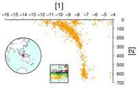
WadatiBenioff zone. andre PDUSGovInteriorUSGS Data source usgs gov USGSNEIC br Created the th February with the free soest hawaii edu GMT software br The WadatiBenioff zone under the Lesser Sunda Islands latitude in degree hypocentre depth in km This plot shows the earthquake localizations on SouthNorth cross section for the