
Related Images


Download:
| Tiny | 98x128 | View | Download |
| Small | 197x256 | View | Download |
| Medium | 395x512 | View | Download |
| Original svg | 612x792 | View | Download |
| Original as jpg | 612x792 | View | Download |
This image was acquired from
wikimedia. It was marked as Public Domain or CC0 and is free to use. To verify, go to the source and check the information there.
Looking for more info about this image?
Try a Google Reverse Image Search for it.
Try a Google Reverse Image Search for it.
Keywords from Image Description:
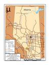
draft Converted.svg en This is map of cities rivers lakes and major roadways in Alberta Canada Canadian census Jesse Moorhouse Central meridian Standard parallels are Projection Canada Albers Equal Area Conic Scale Created by Jesse Moorhouse using data from the Canadian census Arcmap and Adobe Illustrator Cs Uncategorized