
Related Images


Download:
| Tiny | 106x128 | View | Download |
| Small | 213x256 | View | Download |
| Medium | 427x512 | View | Download |
| Large | 854x1024 | View | Download |
| Original png | 968x1160 | View | Download |
| Original as jpg | 968x1160 | View | Download |
This image was acquired from
wikimedia. It was marked as Public Domain or CC0 and is free to use. To verify, go to the source and check the information there.
Looking for more info about this image?
Try a Google Reverse Image Search for it.
Try a Google Reverse Image Search for it.
Keywords from Image Description:
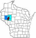
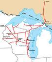
Wisconsin Central map. Route map of the Wisconsin Central Railroad operations in North America in Map created by Sean Lamb User Slambo based on map in the Wisconsin Central Railroad's Annual Report Political boundaries cropped from Image USstateoutlinemap railroad route and city locations and names added using the GIMP own assumed