Related Images


Download:
| Tiny | 110x128 | View | Download |
| Small | 220x256 | View | Download |
| Medium | 441x512 | View | Download |
| Large | 883x1024 | View | Download |
| Original | 1167x1352 | View | Download |
This image was acquired from
wikimedia. It was marked as Public Domain or CC0 and is free to use. To verify, go to the source and check the information there.
Looking for more info about this image?
Try a Google Reverse Image Search for it.
Try a Google Reverse Image Search for it.
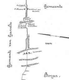
Keywords from Image Description:
Zandbergen Drouwenerzand. nl Grens tussen Gasselte en Borger getekend in fragment nl Kadastrale Atlas van Drenthe Stichting Kadastrale Atlas van Drenthe Dl Gasselte ISBN Eisveld landmeter Old maps of Drenthe maps of Aa en Hunze Maps of BorgerOdoorn PDold Drouwenerzand natuurgebied