
Related Images


Download:
| Tiny | 166x128 | View | Download |
| Small | 332x256 | View | Download |
| Medium | 664x512 | View | Download |
| Large | 1329x1024 | View | Download |
| Original | 2160x1664 | View | Download |
This image was acquired from
wikimedia. It was marked as Public Domain or CC0 and is free to use. To verify, go to the source and check the information there.
Looking for more info about this image?
Try a Google Reverse Image Search for it.
Try a Google Reverse Image Search for it.
Keywords from Image Description:
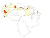
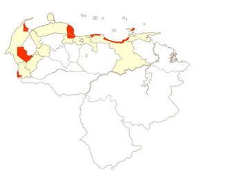
Zonasafectadastragediavargas. Mapa realizado por el usuario Venex en el cual se muestran las zonas afectadas por el desastre en rojo los estados afectados en un color claro Mapa hecho segn el informe del desastre own assumed Venex Maps of the history of Venezuela Vargas debris flows