
Related Images

Download:
| Tiny | 168x128 | View | Download |
| Small | 336x256 | View | Download |
| Medium | 673x512 | View | Download |
| Large | 1347x1024 | View | Download |
| Original | 2322x1764 | View | Download |
This image was acquired from
wikimedia. It was marked as Public Domain or CC0 and is free to use. To verify, go to the source and check the information there.
Looking for more info about this image?
Try a Google Reverse Image Search for it.
Try a Google Reverse Image Search for it.
Keywords from Image Description:
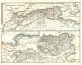
MalteBrun Map of North Africa or Barbary Geographicus AfricaNorthmb. This is beautiful hand colored map of Northern Africa and the Mediterranean the region known as Barbary Includes much of the Sahara along with good deatial on the ancient caravan routes between Fezzan Morocco and points south All text is in French Size in