
Related Images


Download:
| Tiny | 105x128 | View | Download |
| Small | 211x256 | View | Download |
| Medium | 422x512 | View | Download |
| Large | 844x1024 | View | Download |
| Original | 2317x2809 | View | Download |
This image was acquired from
wikimedia. It was marked as Public Domain or CC0 and is free to use. To verify, go to the source and check the information there.
Looking for more info about this image?
Try a Google Reverse Image Search for it.
Try a Google Reverse Image Search for it.
Keywords from Image Description:
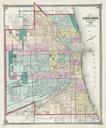
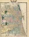
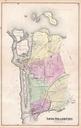
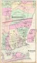
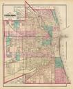
Chicago map by Warner Beers. This map of the Chicago is color coded by ward The map shows the city just two year after the great Chicago Fire of Each street is labeled and all railroad lines are noted throughout the map Park and boulevards are colored in green and the reaches of the city is outlined in red line extending northeast