
Related Images


Download:
| Tiny | 163x128 | View | Download |
| Small | 326x256 | View | Download |
| Medium | 653x512 | View | Download |
| Original | 1042x816 | View | Download |
This image was acquired from
wikimedia. It was marked as Public Domain or CC0 and is free to use. To verify, go to the source and check the information there.
Looking for more info about this image?
Try a Google Reverse Image Search for it.
Try a Google Reverse Image Search for it.
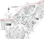
Keywords from Image Description:
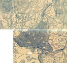
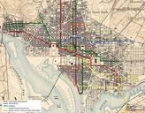
WDC Streetcar Map. English This map is combination of two Geological Service maps The Northwest Quadrant of the Upper MarlboroEast Washington DC Quadrangle map and the Northeast Quadrant of the West Washington DC Quadrangle map These were then modified cut drawn on and legend added URLs maptech cfm fname wwshne state DC and