
Related Images


Download:
| Tiny | 135x128 | View | Download |
| Small | 271x256 | View | Download |
| Medium | 542x512 | View | Download |
| Large | 1084x1024 | View | Download |
| Original | 1525x1440 | View | Download |
This image was acquired from
wikimedia. It was marked as Public Domain or CC0 and is free to use. To verify, go to the source and check the information there.
Looking for more info about this image?
Try a Google Reverse Image Search for it.
Try a Google Reverse Image Search for it.
Keywords from Image Description:
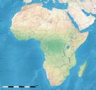
Africa land cover location map. Simulated land cover map of Africa showing the natural aspect of the land with bathymetry as it could be seen from space for geolocation purposes Borders as in July Carte de la couverture du sol simule de l'Afrique montrant l'aspect naturel des terres telles qu'elles seraient vues depuis l'espace