
Related Images


Download:
| Tiny | 126x128 | View | Download |
| Small | 252x256 | View | Download |
| Medium | 505x512 | View | Download |
| Large | 1011x1024 | View | Download |
| Original png | 2116x2142 | View | Download |
| Original as jpg | 2116x2142 | View | Download |
This image was acquired from
wikimedia. It was marked as Public Domain or CC0 and is free to use. To verify, go to the source and check the information there.
Looking for more info about this image?
Try a Google Reverse Image Search for it.
Try a Google Reverse Image Search for it.
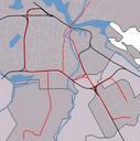
Keywords from Image Description:
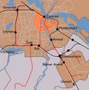
Amsterdam train map. Map of Amsterdam's train stations Greyish orange background denotes the municipality of Amsterdam bright orange is the AmsterdamCentrum district Black lines are railways and red lines are metro lines Dashed red line is metro line under construction to be opened Black dots are the train stations Map of Amsterdam