
Related Images


Download:
| Tiny | 83x128 | View | Download |
| Small | 167x256 | View | Download |
| Medium | 335x512 | View | Download |
| Large | 671x1024 | View | Download |
| Original | 3920x5976 | View | Download |
This image was acquired from
wikimedia. It was marked as Public Domain or CC0 and is free to use. To verify, go to the source and check the information there.
Looking for more info about this image?
Try a Google Reverse Image Search for it.
Try a Google Reverse Image Search for it.
Keywords from Image Description:
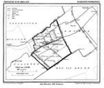
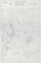
Arsenal Town MAP Part . en Arsenal Town preliminary plan feet to inch Plan for Tuggeranong Canberra during world war The map extends north from Greenway into what is now Kambah and includes Tuggeranong Creek and Village Creek plan drawn for committee gov au mapcdhs Part sgd Morell Town Planner PDAustralia Tuggeranong Australian