
Related Images


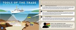


Download:
| Tiny | 165x128 | View | Download |
| Small | 331x256 | View | Download |
| Medium | 662x512 | View | Download |
| Large | 1325x1024 | View | Download |
| Original | 6600x5100 | View | Download |
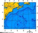
This image was acquired from
wikimedia. It was marked as Public Domain or CC0 and is free to use. To verify, go to the source and check the information there.
Looking for more info about this image?
Try a Google Reverse Image Search for it.
Try a Google Reverse Image Search for it.
Keywords from Image Description:
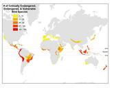
Bird hotspots. Map shows biodiversity hotspots as defined by Conservation International with color coding indicating number of Critically Endangered Endangered and Threatened bird species occurring in these areas Based on GIS data provided at biodiversityhotspots org xml cagn not applicable Bird distribution maps Ornithology