
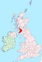
Related Images


Download:
| Tiny | 72x128 | View | Download |
| Small | 144x256 | View | Download |
| Medium | 289x512 | View | Download |
| Large | 578x1024 | View | Download |
| Original svg | 672x1189 | View | Download |
| Original as jpg | 672x1189 | View | Download |
This image was acquired from
wikimedia. It was marked as Public Domain or CC0 and is free to use. To verify, go to the source and check the information there.
Looking for more info about this image?
Try a Google Reverse Image Search for it.
Try a Google Reverse Image Search for it.
Keywords from Image Description:
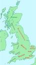
British kingdoms .svg en This map shows kingdoms in the island of Great Britain at about the year The colors indicate ethnic groups WESSEXGWYNEDDFORTRIU Picts green selfmade Vectorized version of Image British kingdoms based on Image Ukmap svg both images are in public domain Sakurambo Maps of AngloSaxon England Maps showing thcentury