
Related Images


Download:
| Tiny | 165x128 | View | Download |
| Small | 331x256 | View | Download |
| Medium | 662x512 | View | Download |
| Original | 800x618 | View | Download |
This image was acquired from
wikimedia. It was marked as Public Domain or CC0 and is free to use. To verify, go to the source and check the information there.
Looking for more info about this image?
Try a Google Reverse Image Search for it.
Try a Google Reverse Image Search for it.
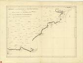
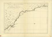
Keywords from Image Description:
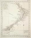
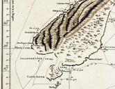
Cook New Zealand South Cape. Southeastern part of the first complete map of New Zealand drawn by James Cook Cook believed that Stewart Island was connected to the South Island and thus named it South Cape nmm ac uk cfm ReproID picture content National Maritime Museum London Collections Online ReproID explored by Lieut Cook Commander