
Related Images


Download:
| Tiny | 197x128 | View | Download |
| Small | 395x256 | View | Download |
| Medium | 790x512 | View | Download |
| Original png | 947x613 | View | Download |
| Original as jpg | 947x613 | View | Download |
This image was acquired from
wikimedia. It was marked as Public Domain or CC0 and is free to use. To verify, go to the source and check the information there.
Looking for more info about this image?
Try a Google Reverse Image Search for it.
Try a Google Reverse Image Search for it.
Keywords from Image Description:
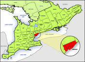
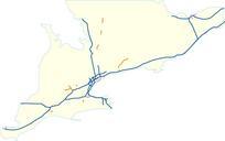
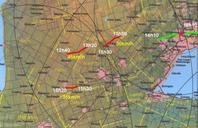
Damages path Southern Ontario. en Map of Southern Ontario between Lake Huron and Lake Ontario showing in red the path of the tornadoes and in green the downpour over Toronto on August th The times are in local time Eastern Daylight Saving which is GMT minus hours In yellow is the speed of motion of the cells that produced them