
Related Images


Download:
| Tiny | 202x128 | View | Download |
| Small | 404x256 | View | Download |
| Original png | 700x443 | View | Download |
| Original as jpg | 700x443 | View | Download |
This image was acquired from
wikimedia. It was marked as Public Domain or CC0 and is free to use. To verify, go to the source and check the information there.
Looking for more info about this image?
Try a Google Reverse Image Search for it.
Try a Google Reverse Image Search for it.
Keywords from Image Description:
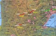
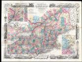
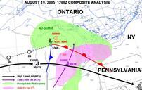
Southern Ontario weather map at GMT. en Situational weather map on the th of August over the Great Lakes bassin low pressure of Wisconsin brings an airmass containing to mm of precipitable water while cold front extending toward the southwest low level jetstream and the left entrance of and upper air jet will all serve as triggers