
Related Images


Download:
| Tiny | 91x128 | View | Download |
| Small | 183x256 | View | Download |
| Medium | 366x512 | View | Download |
| Large | 733x1024 | View | Download |
| Original | 888x1240 | View | Download |
This image was acquired from
wikimedia. It was marked as Public Domain or CC0 and is free to use. To verify, go to the source and check the information there.
Looking for more info about this image?
Try a Google Reverse Image Search for it.
Try a Google Reverse Image Search for it.
Keywords from Image Description:
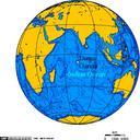
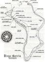
Diego Garcia Island Map. en Diego Garcia Island Map from around This is FIGURE Diego Garcia Island Map from the source document 'Local Area Forecaster's Handbook for Diego Garcia' globalsecurity org doc NAVCENTMETOCDETDGINST APR US Navy Naval Central Meteorology and Oceanography Detachment Diego Garcia other versions PDUSGovMilitaryNavy