
Related Images


Download:
| Tiny | 120x128 | View | Download |
| Small | 240x256 | View | Download |
| Medium | 481x512 | View | Download |
| Large | 963x1024 | View | Download |
| Original png | 1432x1522 | View | Download |
| Original as jpg | 1432x1522 | View | Download |
This image was acquired from
wikimedia. It was marked as Public Domain or CC0 and is free to use. To verify, go to the source and check the information there.
Looking for more info about this image?
Try a Google Reverse Image Search for it.
Try a Google Reverse Image Search for it.
Keywords from Image Description:
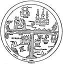
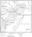
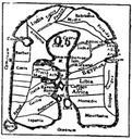
EB Map Fig . Fig Map of Albi th century From codex in the Library of the archdiocese of Albi department of Tarn with its placenames derived largely from Paulus Orosius's Historiae adversum paganos Used by the EB to demonstrate the loss of geographical knowledge during the Dark Ages Map in the Encyclopaedia Britannica thed Vol