
Related Images


Download:
| Tiny | 176x128 | View | Download |
| Small | 353x256 | View | Download |
| Medium | 706x512 | View | Download |
| Original png | 1031x747 | View | Download |
| Original as jpg | 1031x747 | View | Download |
This image was acquired from
wikimedia. It was marked as Public Domain or CC0 and is free to use. To verify, go to the source and check the information there.
Looking for more info about this image?
Try a Google Reverse Image Search for it.
Try a Google Reverse Image Search for it.
Keywords from Image Description:
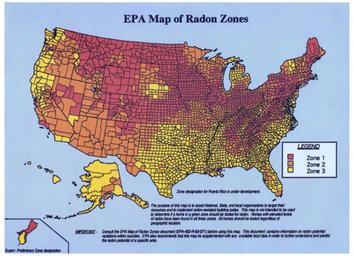
EPA Map of Radon Zones. en map showing the differing radon levels across the United States Zone predicts the highest radon gas levels indoor whereas Zone predicts the least Environmental Protection Agency EPA PDUSGov Uploaded with Maps of the United States