
Related Images


Download:
| Tiny | 163x128 | View | Download |
| Small | 327x256 | View | Download |
| Medium | 654x512 | View | Download |
| Original | 1024x801 | View | Download |
This image was acquired from
wikimedia. It was marked as Public Domain or CC0 and is free to use. To verify, go to the source and check the information there.
Looking for more info about this image?
Try a Google Reverse Image Search for it.
Try a Google Reverse Image Search for it.
Keywords from Image Description:
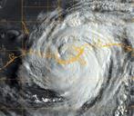
Official U.S. Navy Imagery GOES infrared satellite image of Hurricane Sandy.. WASHINGTON Oct GOES infrared satellite image of Hurricane Sandy provided by the Naval Research Laboratory NRL in Monterey Calif shows the storm at approximately EST in the Atlantic Ocean Navy photo NZZ Join the conversation facebook www facebook