
Related Images


Download:
| Tiny | 139x128 | View | Download |
| Small | 279x256 | View | Download |
| Medium | 558x512 | View | Download |
| Large | 1117x1024 | View | Download |
| Original | 10513x9635 | View | Download |
This image was acquired from
flickr. It was marked as Public Domain or CC0 and is free to use. To verify, go to the source and check the information there.
Looking for more info about this image?
Try a Google Reverse Image Search for it.
Try a Google Reverse Image Search for it.
Keywords from Image Description:
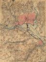
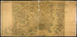
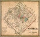
text photo border outdoor GSA Topographical map of the original District of Columbia and environs showing the fortifications around the city of Washington D.C. Created by E.G. Arnold G. Woolworth Colton New York . Courtesy of the Library of Congress. GSA Topographical map of the original District of Columbia and environs showing