
Related Images


Download:
| Tiny | 191x128 | View | Download |
| Small | 382x256 | View | Download |
| Medium | 765x512 | View | Download |
| Large | 1530x1024 | View | Download |
| Original svg | 2323x1554 | View | Download |
| Original as jpg | 2323x1554 | View | Download |
This image was acquired from
wikimedia. It was marked as Public Domain or CC0 and is free to use. To verify, go to the source and check the information there.
Looking for more info about this image?
Try a Google Reverse Image Search for it.
Try a Google Reverse Image Search for it.
Keywords from Image Description:
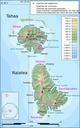
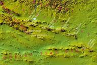
Gobian Altai topography.svg en Digital Elevation Model comes from the NASA SRTM database original DEM was resampled to the size pixel size and filtered next shadowing was applied own Bogomolov PL Topographic maps of Mongolia SVG maps of Mongolia