
Related Images


Download:
| Tiny | 127x128 | View | Download |
| Small | 255x256 | View | Download |
| Medium | 510x512 | View | Download |
| Original | 578x580 | View | Download |
This image was acquired from
wikimedia. It was marked as Public Domain or CC0 and is free to use. To verify, go to the source and check the information there.
Looking for more info about this image?
Try a Google Reverse Image Search for it.
Try a Google Reverse Image Search for it.
Keywords from Image Description:
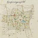
Historische Karte Groziegenfeld. de Historische Karte von Groziegenfeld bayerischelandesbibliothekonline de Adolph Seeberger thumb left thumb PDold Groziegenfeld Maps by Royal Bavarian Land Tax Commission