
Related Images


This image was acquired from
wikimedia. It was marked as Public Domain or CC0 and is free to use. To verify, go to the source and check the information there.
Looking for more info about this image?
Try a Google Reverse Image Search for it.
Try a Google Reverse Image Search for it.
Keywords from Image Description:
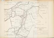
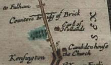
Holland House in an Ogilby map . Holland House shown oriented with west upwards on John Ogilby's map of the route from London to Bristol as Earl of Hollands Also visible are bridge over Counter's Creek and St Mary Abbots church Britannia Atlas John Ogilby File John Ogilby The Road from London to the City of Bristol Custom marker