
Related Images


Download:
| Tiny | 176x128 | View | Download |
| Small | 352x256 | View | Download |
| Medium | 705x512 | View | Download |
| Original svg | 806x585 | View | Download |
| Original as jpg | 806x585 | View | Download |
This image was acquired from
wikimedia. It was marked as Public Domain or CC0 and is free to use. To verify, go to the source and check the information there.
Looking for more info about this image?
Try a Google Reverse Image Search for it.
Try a Google Reverse Image Search for it.
Keywords from Image Description:
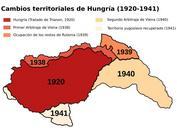
HungraCambiosTerritoriales.svg es Hungra en entreguerras cambios territoriales adaptado del mapa del usuario Panonian Hungarymap UTC Hungarymap User PANONIAN derivative work Rowanwindwhistler talk px svg version rowanwindwhistler Hungarymap Original upload log This image is derivative work of the following images File Hungarymap