
Related Images


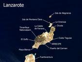
This image was acquired from
wikimedia. It was marked as Public Domain or CC0 and is free to use. To verify, go to the source and check the information there.
Looking for more info about this image?
Try a Google Reverse Image Search for it.
Try a Google Reverse Image Search for it.
Keywords from Image Description:
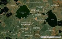
Lanzarote Satellitenkarte. Satellitenbild Lanzarote Ortsnamen selbst erstellt mit nasa gov NASA Visible Earth als Quelle fr die Karte Mex de Public Domain PDUSGov Original upload log de Ireas CommonsHelper page de Lanzarote Mex bytes no Lanzarote Satellite pictures of Lanzarote Satellite pictures of volcanoes of Spain