
Related Images


Download:
| Tiny | 201x128 | View | Download |
| Small | 402x256 | View | Download |
| Medium | 804x512 | View | Download |
| Original | 1448x922 | View | Download |
This image was acquired from
wikimedia. It was marked as Public Domain or CC0 and is free to use. To verify, go to the source and check the information there.
Looking for more info about this image?
Try a Google Reverse Image Search for it.
Try a Google Reverse Image Search for it.
Keywords from Image Description:
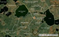
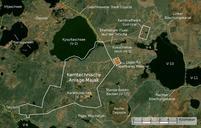
Majak Satellitenkarte. en Satellite image of the Mayak nuclear facility the closed town of Ozyorsk Chelyabinsk different lakes and reservoirs and the South Urals nuclear power plant Based on screenshot from NASA World Wind Landsat Global Mosaic visual layer color corrected de Satellitenfoto der kerntechnischen Anlage Majak der geschlossenen