
Related Images


Download:
| Tiny | 79x128 | View | Download |
| Small | 159x256 | View | Download |
| Medium | 319x512 | View | Download |
| Large | 638x1024 | View | Download |
| Original | 998x1600 | View | Download |
This image was acquired from
wikimedia. It was marked as Public Domain or CC0 and is free to use. To verify, go to the source and check the information there.
Looking for more info about this image?
Try a Google Reverse Image Search for it.
Try a Google Reverse Image Search for it.
Keywords from Image Description:
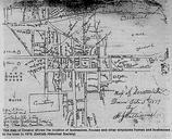
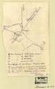
Map Browning Court House and environs DeKalb County Georgia. en Hand drawn map with commentary indicating route of Federal Troops under the command of General Sherman in and about the area of Brownings Courthouse Tucker Georgia and Henderson Mill Road miles distance July Library of Congress Union Army American Civil War other