
Related Images


Download:
| Tiny | 186x128 | View | Download |
| Small | 373x256 | View | Download |
| Original gif | 416x285 | View | Download |
| Original as jpg | 416x285 | View | Download |
This image was acquired from
wikimedia. It was marked as Public Domain or CC0 and is free to use. To verify, go to the source and check the information there.
Looking for more info about this image?
Try a Google Reverse Image Search for it.
Try a Google Reverse Image Search for it.
Keywords from Image Description:
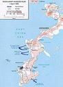
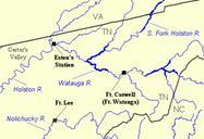
Mapcherokeeinvasionwatauga. en Map showing major locations during the Cherokee invasion of the Overmountain settlements modern northeast Tennessee in at the outset of the American Revolution Fort Caswell later called Fort Watauga was located at modern Elizabethton Tennessee Fort Lee was located along the Nolichucky near modern Limestone