
Related Images


This image was acquired from
wikimedia. It was marked as Public Domain or CC0 and is free to use. To verify, go to the source and check the information there.
Looking for more info about this image?
Try a Google Reverse Image Search for it.
Try a Google Reverse Image Search for it.
Keywords from Image Description:
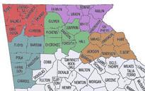
MockupforMapRenderExtension. en mockup of the output that map overlay extension could create Map taken from Census Buerro census gov lat lon wid ht iht iwd mlat mlon msym bigdot on CITIES GRID interstate statehwy ushwy and modified with Photoshop and Illustrator meta Original uploader was Plowboylifestylemeta meta