
Related Images


Download:
| Tiny | 85x128 | View | Download |
| Small | 170x256 | View | Download |
| Medium | 341x512 | View | Download |
| Large | 682x1024 | View | Download |
| Original png | 691x1037 | View | Download |
| Original as jpg | 691x1037 | View | Download |
This image was acquired from
wikimedia. It was marked as Public Domain or CC0 and is free to use. To verify, go to the source and check the information there.
Looking for more info about this image?
Try a Google Reverse Image Search for it.
Try a Google Reverse Image Search for it.
Keywords from Image Description:
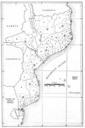
Mozambique map of the administrative divisions circa . Mozambique circa The Area Handbook for Mozambique US Government Printing Office Author LEGEND Loureno Marques District Townships concelhos Loureno Marques Manhia Maputo Bela Vista Marracuene Vila Lusa Matola Namaacha Sbi Moamba Gaza District Townships concelhos Gaza Joo Belo