
Related Images


This image was acquired from
wikimedia. It was marked as Public Domain or CC0 and is free to use. To verify, go to the source and check the information there.
Looking for more info about this image?
Try a Google Reverse Image Search for it.
Try a Google Reverse Image Search for it.
Keywords from Image Description:
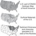
NGMDB Regional maps support. en Figure Regional maps whose compilation and GIS development is supported by the NGMDB The uppermost map the Geologic Map of North America is discussed in the text The center map is in press Soller and Reheis in press and must be converted to database The database for the lower map is published Soller