
Related Images


Download:
| Tiny | 88x128 | View | Download |
| Small | 176x256 | View | Download |
| Medium | 352x512 | View | Download |
| Large | 704x1024 | View | Download |
| Original | 1321x1920 | View | Download |
This image was acquired from
wikimedia. It was marked as Public Domain or CC0 and is free to use. To verify, go to the source and check the information there.
Looking for more info about this image?
Try a Google Reverse Image Search for it.
Try a Google Reverse Image Search for it.
Keywords from Image Description:
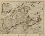
North America corrected from the observations communicated to the Royal Society at London and the Royal Academy at Paris. en map of North America Central America and the Caribbean showing the Gulf of Mexico and the Atlantic Ocean and parts of South America TPL torontopubliclibrary ca jsp Entt RDMDCS DCS North America corrected