
Related Images


This image was acquired from
wikimedia. It was marked as Public Domain or CC0 and is free to use. To verify, go to the source and check the information there.
Looking for more info about this image?
Try a Google Reverse Image Search for it.
Try a Google Reverse Image Search for it.
Keywords from Image Description:
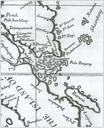
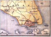
PedraBrancaMapofMalaya. Detail of map of Malaya British Malaya by the Surveyor General of the Federated Malay States and Straits Settlements showing Singapore part of the Straits Settlements shaded in red and Johor one of the Unfederated Malay States in orange The island of Pedra Branca appears on the right of the map marked Pedra