
Related Images


This image was acquired from
wikimedia. It was marked as Public Domain or CC0 and is free to use. To verify, go to the source and check the information there.
Looking for more info about this image?
Try a Google Reverse Image Search for it.
Try a Google Reverse Image Search for it.
Keywords from Image Description:
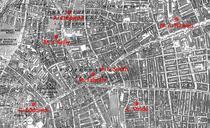
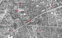
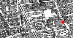
Spitalfields rookery. en ordnance survey map of Whitechapel showing the area around en Spitalfields where many common lodginghouses were situated in the late Victorian era Red circle indicates the location at the junction of Osborn Street and en Brick Lane near where en Emma Elizabeth Smith the first en Whitechapel murders victim