
Related Images


Download:
| Tiny | 230x128 | View | Download |
| Small | 461x256 | View | Download |
| Medium | 923x512 | View | Download |
| Original svg | 1152x639 | View | Download |
| Original as jpg | 1152x639 | View | Download |
This image was acquired from
wikimedia. It was marked as Public Domain or CC0 and is free to use. To verify, go to the source and check the information there.
Looking for more info about this image?
Try a Google Reverse Image Search for it.
Try a Google Reverse Image Search for it.
Keywords from Image Description:
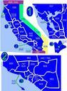
SR area history.svg This is map of the highways on the east side of Mount Rainier in Washington The road on the north now SR was added to the state highway system in and moved south in the road on the south now US and SR was added in and shifted west in and Current US east of SR was readded in Email me if you would like