
Related Images


Download:
| Tiny | 163x128 | View | Download |
| Small | 326x256 | View | Download |
| Medium | 653x512 | View | Download |
| Large | 1306x1024 | View | Download |
| Original | 2292x1796 | View | Download |
This image was acquired from
wikimedia. It was marked as Public Domain or CC0 and is free to use. To verify, go to the source and check the information there.
Looking for more info about this image?
Try a Google Reverse Image Search for it.
Try a Google Reverse Image Search for it.
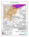
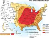
Keywords from Image Description:
Wind Zone Map . Wind zone map shows how the frequency and strength of extreme windstorms vary across the United States Wind speeds in Zone IV red where the risk of extreme windstorms is greatest can be as high as miles per hour See also nist gov cfm www nist gov cfm Credit Federal Emergency Management Agency Disclaimer Any mention